
Difficulty: Class 3
Exposure: Exposure at summit
Summit Elevation: 14,252'
Elevation Gain: 4400' from trailhead; 3300' from Kilpacker Basin camp at 11,000'
Round Trip: 12.5 miles from trailhead; 4.5 miles from Kilpacker Basin camp
Trailhead: Kilpacker at 10,100'
Climbers: Rick Crandall; Rick Peckham | September 5, 2017
Mount Wilson is considered the signature mountain of the rugged San Juan Range. It is ranked somewhere in the top 5 in difficulty of all the Colorado fourteeners.
The USDA cautions as follows:
At 14,252 feet, Mount Wilson is often ranked among the most difficult fourteeners in Colorado. You'll need to break out all your mountaineering skills here, as the climb almost always involves snow travel with ice axes and up and down scrambling. There are also four small glaciers at the summit of Mount Wilson, which add to the weather conditions and elements that you'll need to be aware of when you attempt the ascent. You'll want to be especially careful along the upper third of the climb, where loose rocks and terrain have caused many deaths over the past few years. Again, attempt this climb earlier in the day, plan for the elements and make sure to have the proper gear with you for the journey.
Summit Post adds: Of those who ascribe to climb all Colorado's fourteen-thousand foot peaks, these three scraggly mountains (Wilsons and El Diente) are generally reserved for the end or close to it. The rock quality on these peaks is questionable at best and loose, rotten and unstable terrain that people come to learn first-hand.
There are also nine rock glaciers which have glacial ice & snow under the extensive rock fields, making for an unstable base of rock movement. The mountain was named for A. D. Wilson, a topographer with the Hayden Survey since he was in the first-ascent party in 1874.

There are several trailheads to access Mt. Wilson, depending on the chosen approach to summit. I favor the Kilpacker trailhead for several reasons including a shorter (3 3/4 mile) backpack to beautiful camping and a climb to summit that avoids the brief but exposed Class 4 pitch on the "standard" approach. If you take this route, when hiking in, be sure to take the right fork 2.25 miles in from trailhead that says: El Diente Peak Route.
Our Mt. Wilson adventure had been delayed several times in this summer of 2017 due to literally daily thunderstorm activity in the high country, compounded by incredible fires in California, Oregon and Montana that beset the entire west in intense smoke. Just after Labor Day I saw a 2-day break in the thunderstorm forecast and a curious corridor of smoke-free terrain in the San Juans - so we went for it.
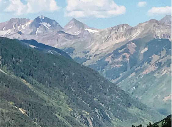
The Kilpacker approach ends in a gorgeous basin that opens into one of the prettiest campsite views anywhere. With El Diente prominent in the upper left (see climb story at: www.rickcrandall.net/el-diente-south-slopes/ )_and a wonderful multi-tier snowmelt waterfall cascading down, the setting couldn't be more impressive.
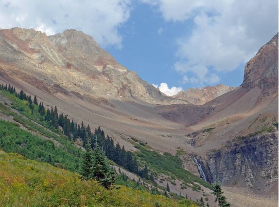
This photo was taken from our campsite, which is in the cluster of trees before the last cluster you see in the photo.
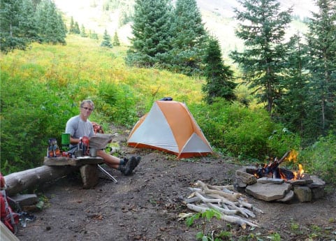
This is our camp. Rick Peckham (Rick P.) found rocks to create a table and a fire ring that are among his signature creations in the backcountry. He does amazing things with cairns as well, while usually waiting for me to catch up with his climbing.
We had a gorgeous view, no smoke, rain or thunder, a warm evening, and even kitchen "furniture." Luxury!!
The Climb
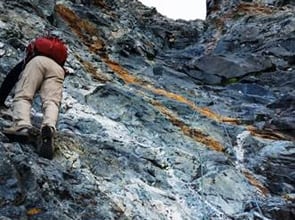
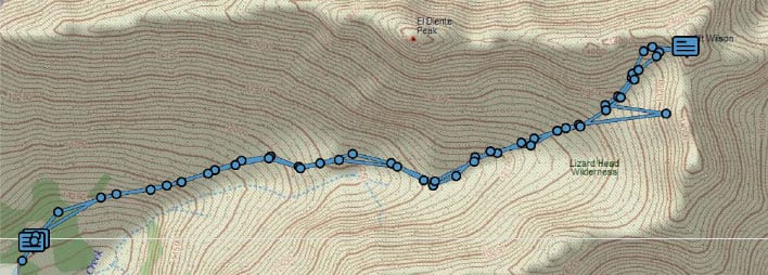
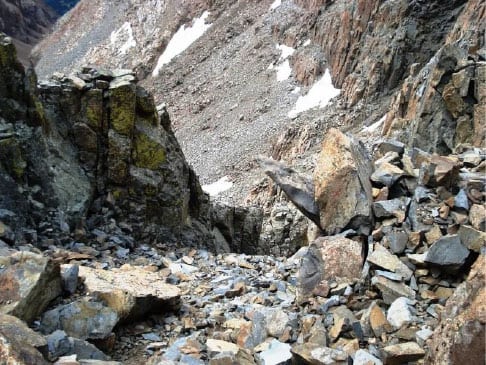
I knew from reputation that this mountain was going to be hard, but I didn't appreciate how ugly the endless boulder field was going to be. I've been on long boulder approaches (like the one leading towards Capitol Peak) but none where the rocks are big, sharp and they move when you step on them. By the end of the day, Rick P. and I fell several times (highly unusual) and got banged around a bit, but fortunately not hurt. Our route, as tracked by my DeLorme InReach GPS device, shows the entire basin - which is literally ALL rocks until the climb to summit - which is more rocks, but steeper and even looser. (The errant blue dot is an error.)
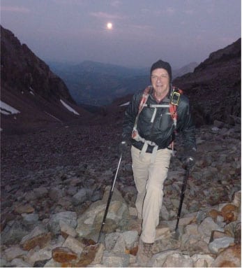
The weather forecast was bouncing around, but acceptable odds for at least a dry morning, so as typical for climbing 14ers, we started early. We were awake at 3pm and on the trail by 3:30am under clear skies and a brilliant full moon that stayed with us all the way until sunrise.
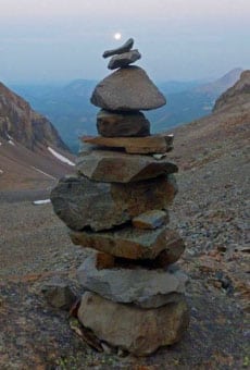
This photo is from Rick P. entertaining himself positioning the moon above this cairn. He does stuff like this while I catch up.
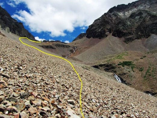
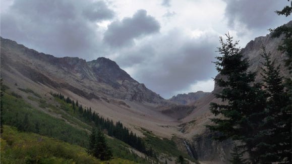
For the first 1500' of vertical gain, we were in moonlit semi-darkness. These two photos were taken in daylight during our descent. This photo shows the rocky start. Notice the multi-tier waterfall all the way up on the right. Very cool

At about 12,500' there is a key trail split that is only marked by two cairns. Go straight up the basin for Mt Wilson (blue), or go left here for El Diente (red). We got here in about 2 hours
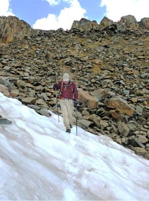
As we proceeded further we got up into the glaciers - the permanent snowfields. The rocks are so awful, I highly recommend bringing spikes (at least microspikes) and hiking up the glaciers. A word of caution - this is steeper than it looks in the photo, so if you have little experience with spikes and snow/ice trekking - stay off it. If you slip, unless you have an ice ax for self-arrest - you'll slide rapidly into the rocks below and it won't turn out well.

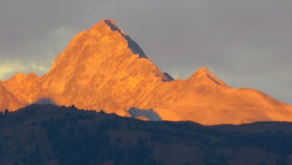
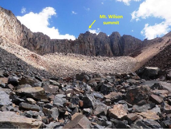
We saw the Mt. Wilson summit (red arrow) for the first time from at about 12,700' and now we had daylight.
Below is a closer look at the summit.


I'll take snow over loose, sharp, endless boulders any time. Early in the morning the snow is quite frozen and icy in places. OK with spikes.
Rats - I ran out of glacier ...

... and there were a ton of rocks to go.
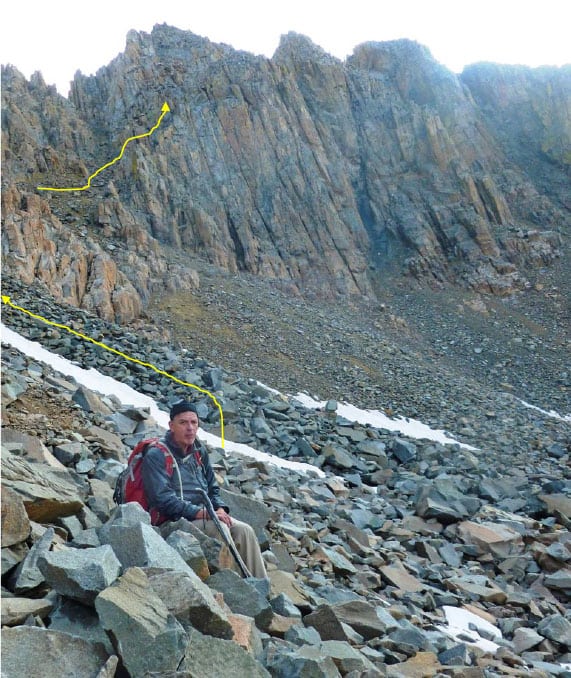
Finally, we got to the top of the basin, here at about 13,500' with still two loose gullies and a rock climb to summit ahead.
Look at those rocks - not a flat surface to be seen.
It was about here I was wondering if I was going to make it up to the top. I've gotten to that mental state on several of the harder mountains. I was actually feeling very fit (after a summer of climbing), good breathing, no aches or pains - and I made mental note that it was only 7:30am and I'd gotten all the way to the top of the basin. The weather was still looking great.
I'd long ago learned that the worst thing you can do while climbing is to look all the way up to summit. It always looks like too big of a task.
So I entered an "incremental" stage of thinking - break it down into pieces. First, just get to the base of the first gully. Don't think about anything else. When I get there, just think about getting up the gully. Then the key rib crossover (more on that later). Then the second gully, etc.

Up the first gully. These approach shots are all of me. Rick P. is a more experienced and stronger climber, so he had the camera out. At this point I dropped the sticks to use hands to pull up on the more solid rock that lined the side of the gullies.

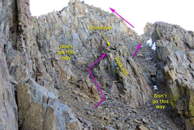
This route entails crossing over a rock rib that separates the lower gully from the upper gully. We had plenty of warning in our research that we needed to find that very same rib crossover on descent to avoid getting off-route and into trouble. So we marked it by tying orange construction tape to a rock (see further on).

The upper gully is steeper, and looser.
Looking back down the gully
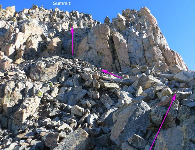
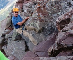
Finally at the top of the upper gully, we turned left to go for the final 150' rock climb to summit. THAT was the fun part of this climb although the rocks were as loose as you hear about in our Elk Range 14ers near Aspen. We were pushing on the rocks to get up rather than pulling in order to avoid a rock coming off with me on it.

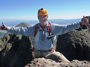
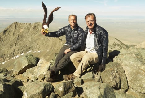
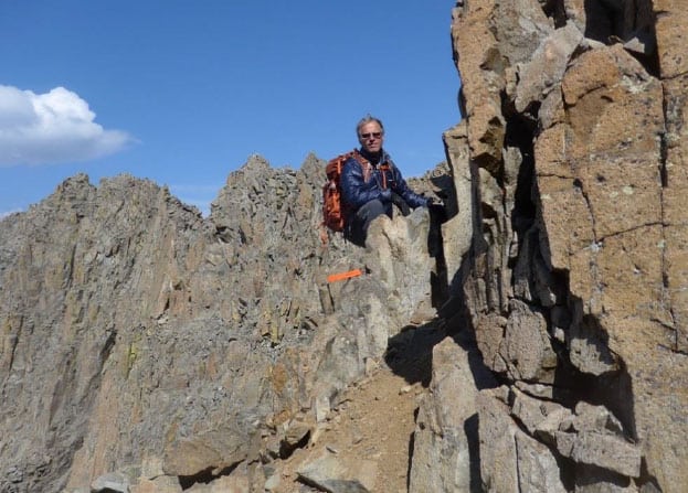
And here's the Mt. Wilson summit - not a lot of room up there, and some pretty decent exposure.

But enough room for the two of us.
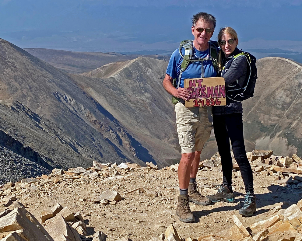
Summit Mt. Wilson 14, 252' at 9:30am, 6 hours and 3300' up from camp.
Behind us is the famous Class 4 traverse ridge from Mt. Wilson to El Diente whose summit is in the photo in the rear left.
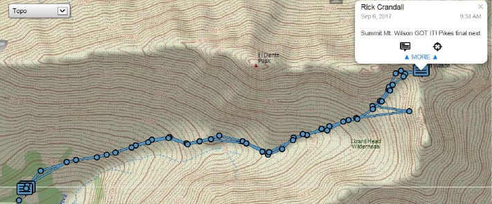
Here is our tracked climb from camp to summit.

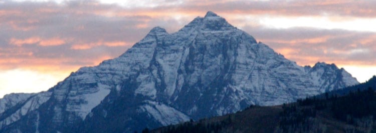
From the Mt. Wilson summit there is Gladstone Peak on the right (a 13er) and Wilson Peak further on the left. That story is at: www.rickcrandall.net/wilson-peak-southwest-ridge-second-try-success
While there's a bit of smoke in the far distance, conditions were really quite clear where we were. That was another stroke of good luck - heavy smoke would have cancelled the climb.
Here is a great photo shot by some friends who were near Silverton the day before our climb that shows Mt. Wilson (left peak) and Wilson Peak (center peak). They texted me this photo which gave me some confidence the smoke would be OK.
The Descent
Rick P. on the rock-rib crossover.
Back to the key rock rib crossover from upper to lower gully. See the orange construction tape Rick P. tied on a rock so we could see it from above. This is a 2'-wide safe way over the rib that is not otherwise differentiated from other ways across it - and that lead to trouble.

On the way down I started getting worried about the weather. I headed right to the glaciers to speed things up.
By 1pm it looked like our luck was running out. Clouds were gathering, it rained a bit, hailed a bit but thunder didn't start until we were only minutes away from tree-line and our camp. We did it - we squeezed in a major mountain right at the end of the summer - my 57th 14er & only one to go.
Without my friend and climbing companion, Rick Peckham, I would not have succeeded in this climb. In the dark he scampered about looking for cairns. In loose gullies and loose Class 3 rock scrambling he tested for stable hand holds ("bombers" as he calls them). But more than anything this climbing thing has been all about enjoying the total experience with friends - the research, planning, weather forecasting, camping, route finding and all the other challenges we've met with enthusiasm to succeed on these amazing and individually-unique mountains. While I'm thankful to many, for this mountain ...
Thank you Rick Peckham.