
Difficulty: Class 2/3
Exposure: significant in one spot
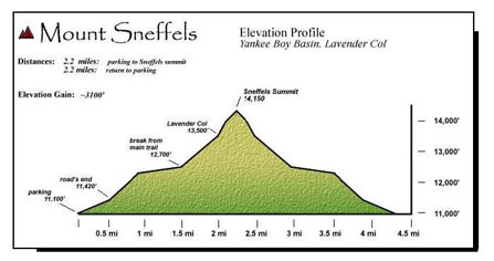
Summit: 14,150 feet
Elevation Gain: 2,100'
Roundtrip: 2.5 miles
Trailhead: Yankee Boy Basin at 12,460'; overnight in Ouray
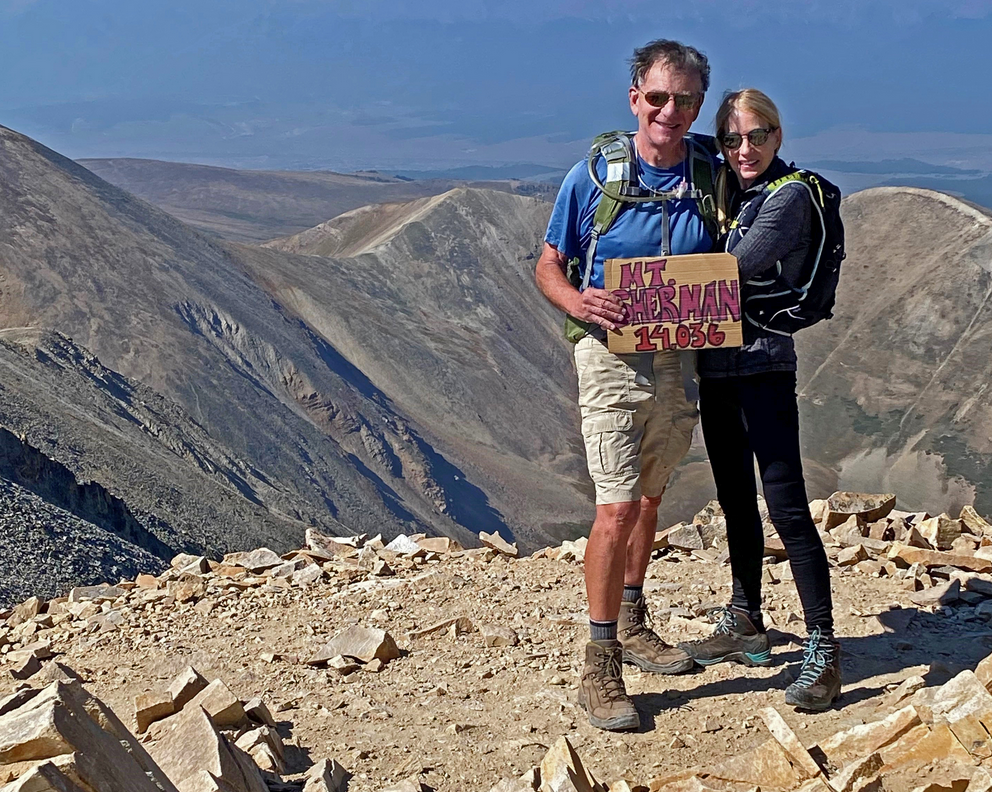
Climbers: Rick Crandall; Shan Stuart; Laura Welch August 20, 2009
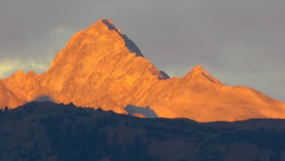
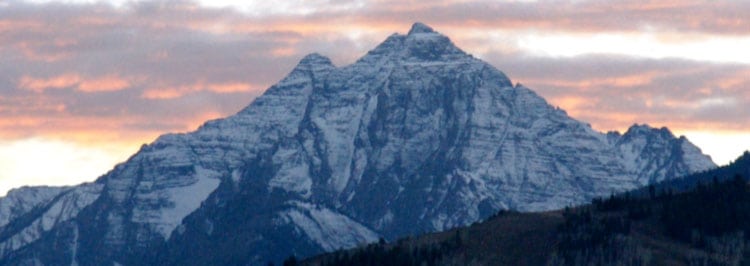
Mt. Sneffels (named after the volcano Snaefell in Iceland) is a few steps up in difficulty from the fourteeners we've been doing. It features Class 3 rock scrambling and a difficult extended scree descent especially where there were "marbles" (small, round stones) on hard packed steeper slopes that were almost impossible to stand up on. However Mt. Sneffels is known as having one of the most beautiful views of all of Colorado's Fourteeners - striking and impressive, caused by spires, mountains, and columnar remains of old volcanoes.
We were three - Shan Stuart, Laura Welch and me. We over-nighted in the town of Ouray to get an early start in the morning. The approach to Ouray is reminiscent of the approach to the Swiss Alps driving from Zurich, and in fact is called the "Switzerland of America" due to its setting surrounded on 3 1/2 sides by tall, rugged mountains.
Ouray has been a special destination of world travelers for more than 100 years. This small community is nestled in some of the most rugged and towering peaks of the Rockies. Set at the narrow head of a valley and surrounded on three sides with 13,000 feet + snowcapped peaks – Ouray has been nicknamed the “Switzerland of America.”

Remarkably, two-thirds of Ouray’s original Victorian structures, both private and commercial, are still occupied, and have been restored.
Centuries before the white man arrived, the Tabeguache Ute, a nomadic band, traveled to what would become Ouray to hunt and to soak in the "sacred miracle waters". Even then, they knew the springs that simmer beneath much of Ouray were therapeutic. The town's original name was "Uncompahgre", the Ute word for "hot water springs." The Spanish explorers named this rugged range the San Juan Mountains. But it was the miners, flooding the region in the late 1800's in search of silver and gold, who would forever change the face of the San Juans.
The legend of Chief Ouray envelops the town that bears his name. The Chief garnered the respect of the Ute Indian Nation, the U.S. Government, and the Indian nations throughout North America because of his intelligence and diplomacy.
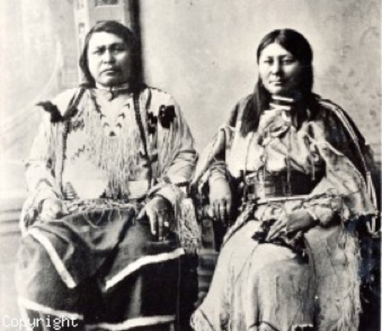
The Greatest Ute Indian Chief Ouray
Ouray was raised in the Taos valley and was influenced by the Spanish way of life. Ouray joined his parents in Colorado at age 17, already speaking Spanish, Ute, Apache, and some English. At 35, he became the chief of the Uncompahgre Ute Tribe.
Ouray believed peace was the best option for his people, but gold, silver, and land were at the heart of what the whites wanted, and the Ute Indians were in the way. By 1880, the year of Chief Ouray’s death, the Utes had lost their land and way of life in the San Juan Mountains.
The jagged peaks that zigzag around Ouray are intersected by highly mineralized veins rich in gold, silver, zinc and other metals. Naturally, these valuable metals attracted immigrant miners from all over the world. The serious “rush” started in the 1870s. Word of the huge silver strikes increased the town’s population from 400 in 1876, to over 2500 by 1890. Its population has rebounded to 1000 in 2010 as a tourist mecca which is the same number of residents in 1877!
Ouray’s mining heyday peaked between 1883 and 1893 with most mines closing by 1923. The town evolved from a miners’ camp to the Grand Madam of the San Juans with the construction of incredibly beautiful buildings. The town’s architectural style was Queen Anne Victorian and is often referred to as the “Gem of the Rockies.”
From Ouray to Trailhead:
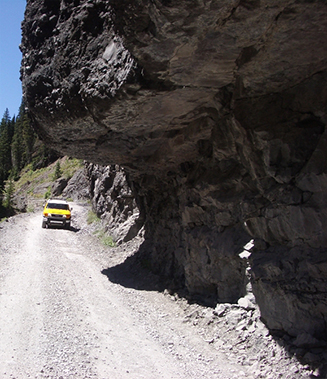
We left town in the dark at about 5:15am in pitch dark and immediately got on the dirt road toward Yankee Boy Basin. We knew we were in for some big time off-roading, but we had Laura's Toyota FJ which was definitely the right equipment. I was the driver, because I like it. We had boulders, major ruts, steep climbs combined with hairpin turns, exposure, overhanging rock - all in the dark - and for over 9 miles. It definitely woke us up.
This should only be attempted by a serious 4WD vehicle with high clearance and short wheelbase - and preferably in daylight.
We went early to get ahead of other climbers since we had so many warnings of loose rock careening down the slopes and injuring (and earlier in the summer killing one) climbers who were below others above. We did get to the trailhead first.
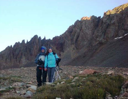
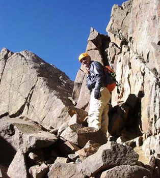
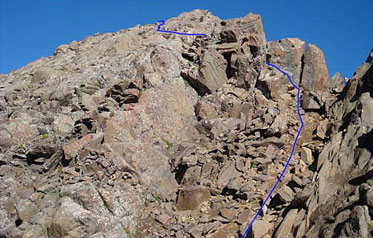
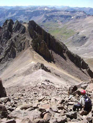
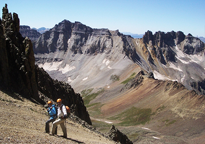
(Shan and Laura) From the trailhead, at 6:35am we started our hike at sunrise. We headed towards the steep scree field you see on the right of the photo. It was chilly, but warmed up later to a beautiful Colorado blue-sky day.
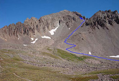
At about 12,600' we were at the base of "Kismet” Mountain (13,694') and ready to head up the scree field.
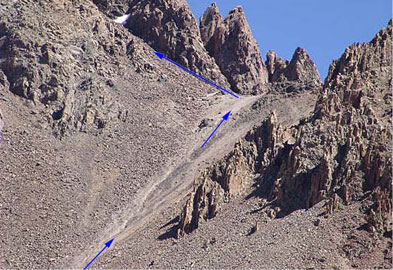
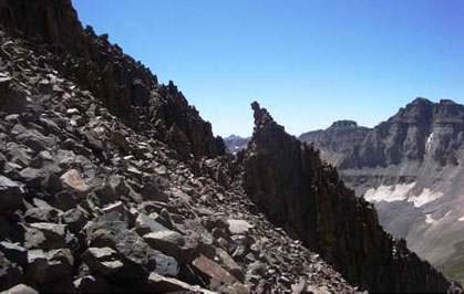
The upper half of the slope leading up to the "Lavender Col", which is kind of a saddle. Rick hated the scree and climbed up the rocks on the left, eventually joining up with the others at the base of the upper blue arrow.

Laura is the tiny climber traversing the top of the col at 13,560' to join up with Rick. You can get a feel for the grade on the lower scree slope - and why Rick avoided it with a Class 3 scramble up the rocky sidewall.

Laura met up with Shan just before meeting up with Rick to ascend the much steeper second couloir. The surrounding geology was breathtaking.
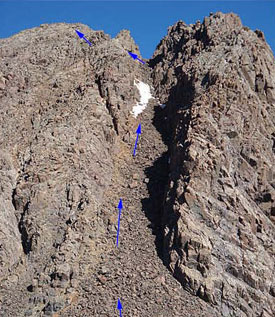
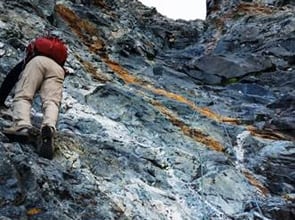
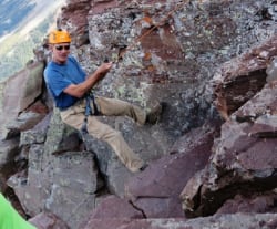
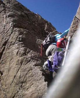
Here was the next challenge - a much steeper gully that ascends to 14,050', also loaded with loose rock. There is no single route up the gully - we went up the right side, at times clinging to the right rock wall.
Rick heading up the gully with the Lavender Col in clear view below.
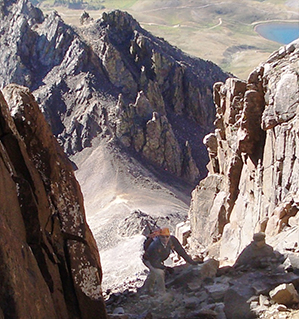
Near the top (approx. 30 feet from the end), we turned left to find a small “V” notch we had to get through to get to the summit. The issue here was that just past the left hand rock in the shadow was open exposure to a steep dropoff into rocks below.

Rick went up first. The idea was – don't look left.
... because if you did you'd see the dropoff to a rocky bottom 50' below.

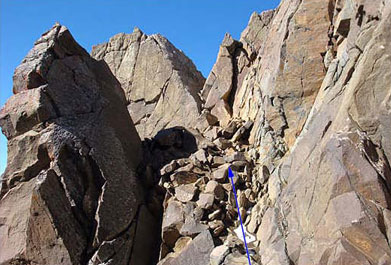
Here's Laura doing it with Shan's assistance.
Past the notch, the climbing is more scrambling, there's about 200' vertical to go to the summit.

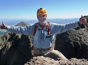
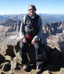
Summit Mt. Sneffels, 14,150' at 9:35 am, 3 hours from trailhead

Summit view of Telluride ski slopes in the distance; Gilpin Peak (13,694') in foreground.
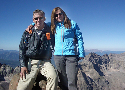
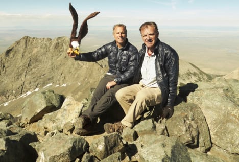
Rick and Laura at the summit.
HAPPY BIRTHDAY SHAN!
What a great birthday you had - we wish you many more.
Rick, Pamela, Laura and lots of doggies ....
The summit of Sneffels is actually pretty small – I’d say a couple square yards before it starts to drop off. The drop on the north side is especially dramatic.
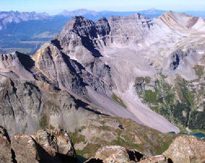
Surrounding views of the nearby 13ers are incredible, as are the views on the horizon of other 14ers. Uncompahgre and Wetterhorn stick out to the east, and the Wilsons, Eolus, and other southwest San Juan 14ers can all be picked out as well.
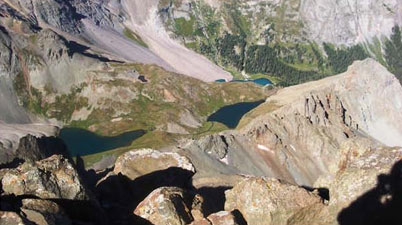
Blue Lakes view from the summit. I hear that is a great hike and camp-out.
After about a half hour of neck-turning views at the top (we were first up, but joined by a half dozen others) we headed down.
That turned out to be another adventure - dear Laura, feeling her oats, led us down but got off route (in fairness - that's pretty easy to do up there) and we wound up on a near vertical pitch trying to locate the top of the "v" notch – which really gave us pause. We saw a climber coming up and asked him to spot our best route from his vantage point. He said "no matter, any way you go is class 4 - take any one of them." I shouted, "But we're not Class 4 climbers," to which he retorted "You are now and have been for a while!"
After we got down that pitch and down-climbed the notch we got excited we'd done it .
Past the notch we down-climbed the upper gully which took some time. Here's Shan on the way down towards the Lavender Col. Laura ripped down and was there waiting for us.
We were advised to hike past that rock pile in the middle of the col and sidestep down the yellow bit - but that was a big mistake. So we had to go off into the loose talus on the far left.
Rick and Laura traversing the col to the other side of the rocks behind us.
This took some time getting down - and a few falls and bruises.
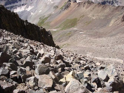
Bottom is in sight, but it's still a long way down.
NOTE: Mount Sneffels is a CLIMB–not a hike!
THE SUMMIT:
The final stretch of 650 feet requires some proficiency in minor rock climbing–and caution.
Be aware of rocks rolling from above and be careful not to dislodge any yourself. Do not linger on the summit–leave time to descend with care. Falls are more dangerous coming down.
ATTRACTIONS AND FEATURES:
This striking 14,150 foot mountain is an inviting destination for many visitors and a successful ascent can be most rewarding. It must be emphasized, however, that this peak has produced fatalities, serious injuries and hazardous rescues. It requires more planning, preparation and skill than the trails described on this website.
Past all the off-road uglies and nearly back to Ouray at about 12:30pm.
Email check. I am OK climbing Mt. Sneffels starting Thurs morning weather permitting 🙂
ESN:0-74774477
Latitude: 38.0036
Longiture: 107.7922
Time: 08/20/2009
15:52:46 (GMT)
Start: 6:37am
Summit: 9:35am
(Spot) 9:53am)
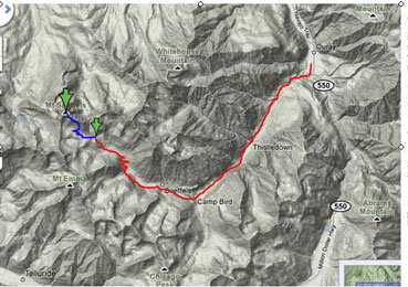
Red line is off – roading;
Blue line is the climb