

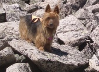

This is early season (June, 2010) for fourteeners (mountains over 14,000’) with snowmelt and rock movement still going on at higher altitudes but the Collegiates near Buena Vista were melting early. So I researched and chose Mt. Princeton for a Father’s Day treat. My two usual hiking buddies dropped out for different reasons, but my well-documented hiking dog Emme (9 years old, loves high mountain hiking) was willing to go with me, so I decided to solo. I’ve done that once before, but after this one I finally decided that’s a bad idea.
The Start: We drove from Aspen over Independence Pass and over-nighted at Buena Vista to get an early start the next morning. With great intentions for an early start, we were up at 5am and made our way to the start of the off-roading, which is the narrow 322 (Mt. Princeton) road. This is 3 miles of significant off-roading requiring a good 4WD vehicle. So the research says to continue a bit further than 3 miles and look for a pull-off to park. Well, at 6am I must not have read the odometer right, and I proceeded to drive on this 100 year old silver mining “road” that basically disintegrated so I figured I’d got it wrong.
However, the road is the width of my 4Runner with no where to turn around – so how about backing down a nearly non-existent road for maybe a half mile with 4’ dips and hairpin turns – my neck didn’t appreciate it and Emme hung on to the center glove box (where she usually insists on perching and “surfing” the curves) with all claws extended. We got back down to 10,980’ were I found a pull off and parked. Because of that, we didn’t get started hiking until 7am, later than I like, because I’m a slow hiker and I like to be off major peaks by noon to avoid electrical storms.
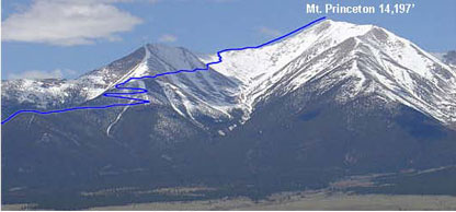
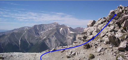
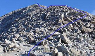
View of Mt. Princeton and the full route.
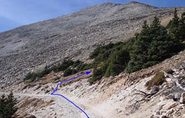
Per instructions: Hike up the rest of the “road.” Near 11,700′, the road comes around the ridge and continues west in poor condition. (That’s why we were hiking and not driving).. After about 1/2 mile, the terrain opens up and you can look up at Unnamed 13,273′ (Princeton not in sight yet). The road curves up to the left and heads south to the Lucky Mine. Find the Princeton trail on the right side of the road, and turn right to climb up the trail.
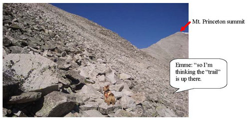
What Path? Here’s where I got fooled by the overall route description. It simply says “continue up to 11,900′ on the ridge. The trail crosses to the north side of the ridge where you can see the Princeton summit off to the west. Continue on the trail as it crosses the north face of Unnamed 13,273′. The trail climbs through rocks and across 4 or 5 gullies that contain snow in spring and early summer).”
Well, the only warnings are “a fall here could send you on a nasty slide (but that’s almost always true). Continue west along the trail and over mostly stable rock.”
“Occasionally, the trail may disappear due to recent rock movement.”
OK, so now here are the clues I should have interpreted as understatements.
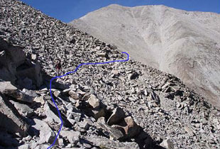
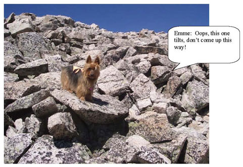
1. “The trail climbs through rocks” – in fact there rarely was a trail – we climbed through 3 miles and 3000’ vertical climb of sharp, large rocks with no let up (see Emme pictures below).
2. “over mostly stable rock” – maybe later in the year, but now in June – you never knew which rock was going to move and at times we were surfing them particularly on the way down.
3. “Occasionally the trail may disappear” – what trail? Take a look at the Emme photos below – that’s the trail. Do you see a trail? Amazingly, using some kind of dog sense, Emme found ways through that were very occasionally marked with cairns indicating that someone thought this was a good way up.
4. Un-interrupted rock for miles all the way to the summit!

Some of these appeared to be fresh rock falls with sharp edges,
so maybe there was a path underneath?
The going was very slow for us, I was being careful because I was solo-ing (which I’ve concluded not to do again). The weather was perfect – can’t imagine navigating these rocks when they’re wet. There were only two other groups of four; each ran into some trouble (story below).
Near 13,300’ we gained the ridge, with stunning views. Then we started climbing up Princeton’s Southeast Ridge which had steeper rocks but more solid until we got to the final approach, which was also steep but very loose.
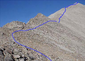
Between 13,600′ and 14,000′, the route gets steeper and looser, which was more of a problem coming back down. Near 14,000′, the final pitch to the summit appears.
Approaching the summit, the rocks just never stopped.
No summit photos of Emme and me because no one else was at the summit.
We only ran into two groups the whole day.
This is the “Spot” message our emergency GPS sends out that tells people we’re either OK or HELP, along with a Google maps link that shows where we are.
Ricks Spot
Latitude:38.74779 Longitude:-106.24071
GPS location Date/Time:06/24/2010 12:15:18 MDT
Message: Rick’s SPOT Check. Emme and I are hiking Mt. Princeton today in the Collegiates – we’re OK
Note the summit time – 12:15, fully 5 hours and 15 minutes from the car – and then we had to come down the same way!
Total hike time was 8 1/2 hours, but about an hour or so was spent with the two different trouble incidents. As we got to the middle of the Ridge we found a guy nearly passed out baking in the sun – he was with a group of four, the other three went on to summit. He clearly had some combination of altitude, de-hydration and exhaustion – he had water – just needed to drink more of it and found some shade under a rock overhang.
The other was on the way down I ran into two girls wandering around at about 13,000’. They were both light-complected, beet red and not at all sure how to get down (remember the non-existent path). They had been with another couple who went on to summit, but hadn’t shown up for three hours. I’d actually run into the other two on the way up. Anyway, these two decided they couldn’t make it to the summit and they remembered a cave further down they wanted to get to for shelter until their friends came down. So we caravanned with them following me and me following Emme!
Amazingly at about 12,000’ just above tree-line we did find that cave and that’s where they plunked. Emme and I went on because we were running out of water and that would not be a good thing. I knew I had Gatorade in the car but we had another 1000’ of downclimbing to go.
We did get there at about 3:30pm, 8 ½ hours of hiking – just as we got to the car Emme spotted a marmot and took off after it with no evidence of the hike in her speed. The marmot ducked into a rock wall and we plopped into our 4Runner for a 3 mile roller coaster ride down Mt. Princeton road to get to pavement and then 1 ½ hours back to Aspen after a very full day.