
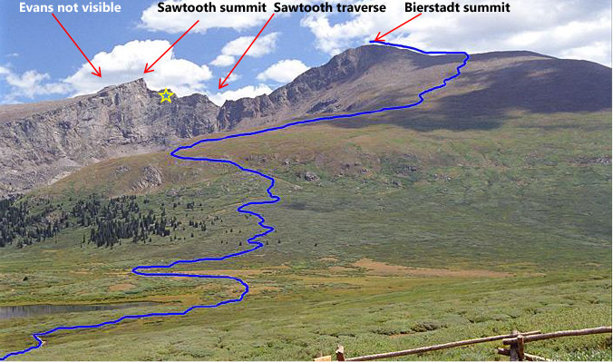
Mt. Bierstadt (14,060’), the Sawtooth (13,750’), Mt. Evans (14,264’)
Difficulty: Class 3
Exposure: some on Sawtooth
Summit:
Mt. Bierstadt 14,060’
Mt. Evans 14,264’
Elevation Gain: 3,900 feet total
Roundtrip: 10.5 miles
Trailhead: Guanella Pass at 11,669’
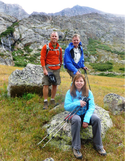
Climbers: Rick Crandall, Rick Peckham, Laura Welch
Mount Evans and Mount Bierstadt are fourteeners that anchor a range known as the Chicago Peaks. Mount Evans is the closest fourteener to Denver and dominates the western skyline along with Longs Peak, Pikes Peak and Mt. Bierstadt. Colorado’s legislature officially named Mt. Evans in honor of John Evans, the second governor of the Colorado Territory from 1862 to 1865. Mt. Bierstadt was named for Albert Bierstadt, a popular painter of Colorado Rockies in the 1800’s.
The Mount Evans Scenic Byway is the highest paved road in North America. It climbs to over 14,100’, just 130’ below the Mt. Evans summit. Building it was so grueling and expensive, at one point in the 1920’s progress stopped with some politicians calling it: “a road that starts nowhere, ends nowhere, and never gets there.”
Despite opposition, construction recommenced: “During the construction season of 1923, the weather was constantly bad, there being practically continuous rain, hail, snow and heavy wet clouds the whole season. The use of heavy construction equipment was impracticable, and the contractor did practically all of the work with station gangs, who,with a shovel, hammer and drill, dynamite and determination, and copious amounts of Copenhagen snuff, literally forced the work through by hand, in spite of every obstacle. ( Wikipedia).” It was completed in 1930.
The road has enabled many high-altitude physics and other science projects. The first accurate measurement of the lifetime of the muon, an elementary particle similar to an electron but with more mass, used sites at Mount Evans in the late 1930’s. This experiment verified the reality of time dilation, one of the key predictions of Einstein’s theory of relativity.
Mount Evans has also been the site of significant research in the life sciences. In 1940, for example, it was the site of a significant study of high-altitude physiology. Pioneering studies on the effects of altitude training on track athletes were conducted on Mount Evans in 1966.
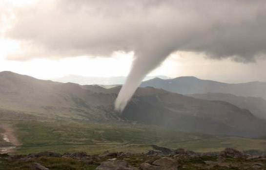
Mt. Evans was recently in the news in 2012 for a rare weather event:
Tornado near Colorado’s Mount Evans rates as second highest on record
Colorado’s high country is not normally associated with tornadoes. Saturday July 28, 2012 however a rare high altitude twister appeared in the skies and touched down only 1.75 miles from the summit of Mt. Evans, and became the second highest altitude tornado ever recorded.
The 2011 Climb
Laura Welch and I, along with Emme, the Crandall’s amazing Australian Terrier who has climbed 17 fourteeners in her ‘career,” first did the ascent to Mt. Bierstadt in July of 2011. At that time we had no designs on the Class 3 Sawtooth traverse to Mt. Evans due to our uncertainty that we had the ability. As it turned out, the weather threatened when we got to the Mt. Bierstadt summit so we wouldn’t have gone on anyway.
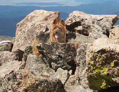
Emme, 10 years old, at the summit of Mt. Bierstadt in July, 2011.
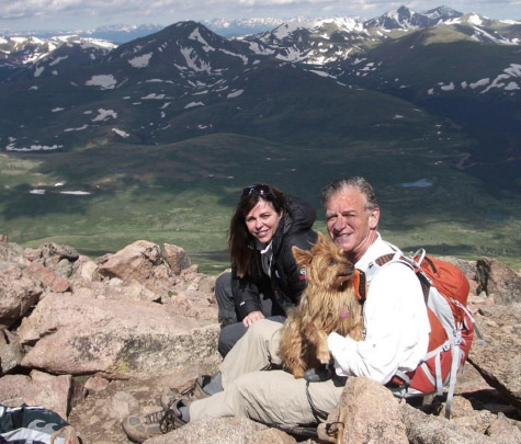
Laura, Rick and Emme at the summit of Mt. Bierstadt, 14,060’ at 10:08 am, 3 hours and 8 minutes from trailhead.
Wind the clock forward to the end of August, 2013. Now we did want to do the Sawtooth and claim the Mt. Evans summit. The monsoon season was still going strong so weather analysis was critical in order to leave enough time in a day to essentially summit three peaks.
Georgetown
The three of us traveled for an overnight in Georgetown, about 40 minutes from Denver, and only 12 miles from the Guanella Pass trailhead.
Georgetown (elev.: 8530’) is a former silver mining camp established in 1859 during the Pike’s Peak Gold Rush. Thousands of mines were dug in the surrounding mountains. The town experienced its greatest growth during the Colorado silver boom of the 1880’s when it rivaled Leadville as the mining capital of Colorado. At one time before the silver boom collapse in 1893, Georgetown’s population was 10,000 and local citizens created a movement attempting to move the state capital there from Denver.
As of the 2000 census, Georgetown had 1088 residents.
The 2013 Climb
To give us the greatest weather advantage, we awoke at 4 am, and got our start at trailhead at 5:30 am in the dark. The 12 mile road to trailhead was incredible. It was paved, with stacked stone walls, immaculate guard rails all the way up – I recalled back to our earlier climb report in July, 2011:
“Lots of construction actually paving this road to nowhere, but must have been “shovel ready” if you know what I mean.”
I’ve seen private driveways leading to $ million homes that don’t look as good.
We headed up the trail in the dark with headlamps on. As dawn approached we could see we were on a very nicely groomed trail with two of our objectives rising in front of us. The hike up to the Bierstadt summit cap was so manicured I’d call it Class 1, with some rock under-foot at you get close to the summit.
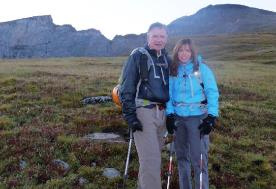
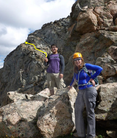
Rick C. and Laura at daybreak. Mt. Bierstadt is on the right and the Sawtooth extends from the left of Rick’s head.
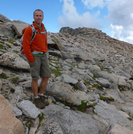
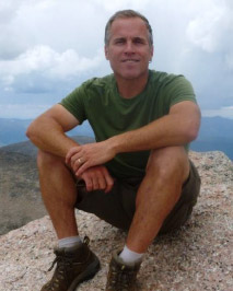
Summit Mt. Bierstadt, 14,060’ at 8:30 am, August 28, 2013, three hours from trailhead.
The skies were clear and the weather looked great so far, but it was only 8:30 in the morning. We stopped for a few photo memories and started down the North side of Bierstadt towards the Sawtooth ridge traverse that would eventually get us to Mt. Evans.
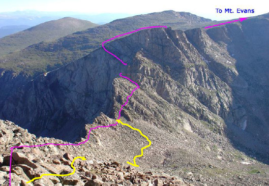
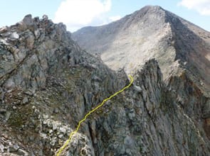
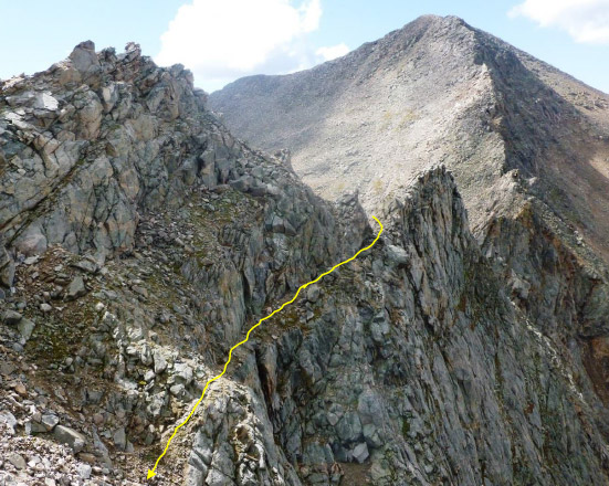
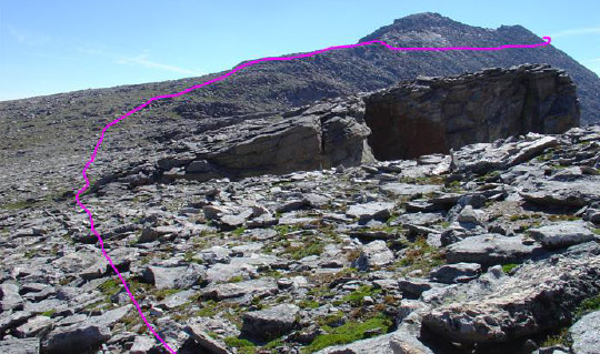
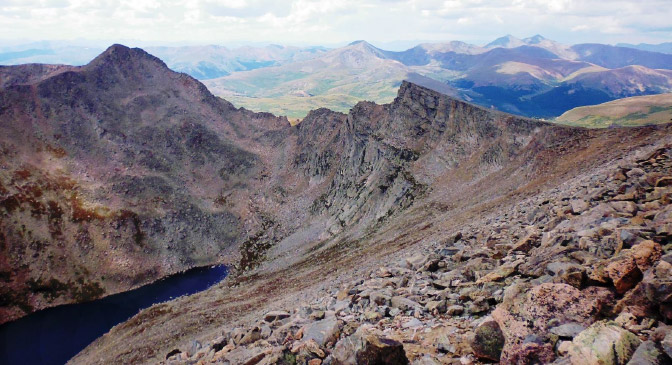
As we headed down to the ridge, unexpectedly there were cairns all over the place and no path, just boulders of increasing size. The “standard” route is shown in pink. Our first target was the lowest notch on the ridge from which the Class 3 terrain begins. We saw cairns marking a lower route (yellow) which we took, but it was no easier.
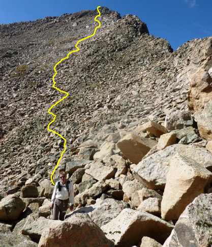
This pitch was much longer than we expected and we probably did too much stopping and route-finding. The sense of distance and elevation relative to that notch gets all distorted when you’re up close and personal to boulders as big as people and extending for a half mile.
We finally decided we’d come down far enough and climbed to the notch on the ridge which was at 13,300’. That was about 800’ down from the Bierstadt summit.
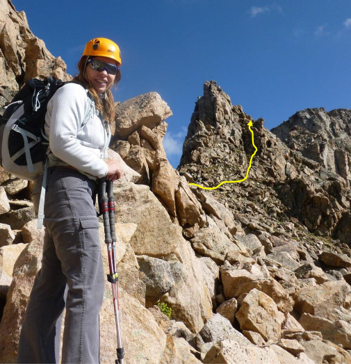
Laura heading around some final rocks to the notch.
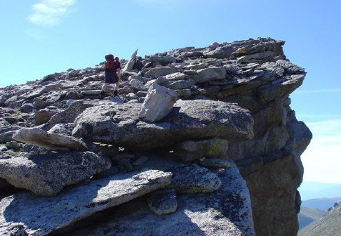
She sees for the first time the beginning of the Class 3 climbing to get over the first obstacle – a “gendarme” guarding the way – typical of what you run into with ridge traverses.
Calling on Faith to Help Out
Here’s a fun part of the story. On the latter part of the ascent of Mt. Bierstadt we’d noticed a solo climber behind us who eventually came within voice range. We exchanged a few comments (we learned his name was Sam) as we were conjecturing about what route to take over the boulders to the ridge. When we got to the beginning of the Class 3 ascent, Laura later told us her inner thoughts were of nervous doubt.
In a later email, she said:
“As I was climbing the Sawtooth there were a few places that had me nervous and in my mind I kept asking God to keep me safe! Sam hiked with us for much of the day and during the Sawtooth he offered me his hand in a few places. As we moved across this challenging area I asked him what he does for a living and he told me he was a Chaplain! My prayer was answered!
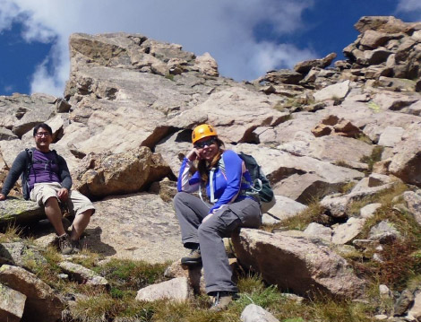
Sam Cho, a hospital chaplain from the University of Colorado Hospital
Sam was a pleasure to meet and chat with throughout the day.
After we got up and past the gendarme, we crossed over the top of the ridge to some ledges on the other side. These were exposed (to drop-offs). We were now on the side of the Sawtooth you see on the way up to Bierstadt (marked by a star on the first photo in this story).
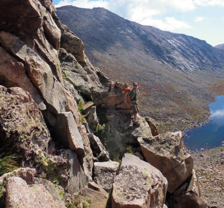
Rick P. starting the ledges and looking back to where we started the day.
These are great shots looking back on the entire route from the distant summit of Mt. Bierstadt. The beginning of the ledges is marked in yellow. That’s what you call “exposure” but the footing was good.
Our next pitch was to ascend a loose, tilted ledge also with lots of exposure on the West side of the Sawtooth.
Laura stayed close to Sam on this pitch as well. Fortunately the previous evening’s storms wetted down the terrain which made for better traction under-foot.
Rick P. led the way up the final loose ledge.
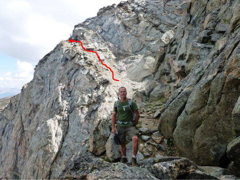
… after we rounded the corner, we approached the top of the Sawtooth,, the highest point of which is a named thirteener at 13,750’
It was 11:15 am. It took us 2 hours 45 minutes to traverse and ascend the Sawtooth from the Bierstadt summit. That included probably a half hour of scratching our heads about what route to take.
We had a very long way to go leaving the Sawtooth to get to the Mt. Evans summit which was still over 1 ½ miles away. We had plenty of Class 2 hiking, much of which was above 14,000’.
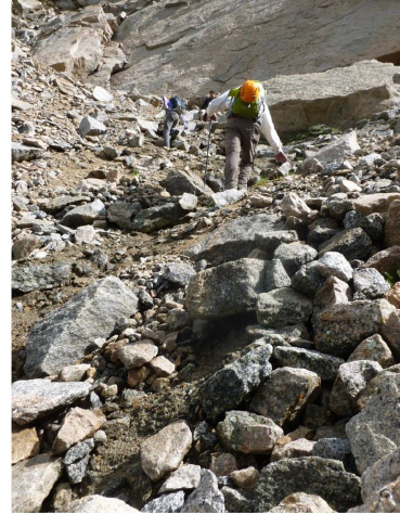
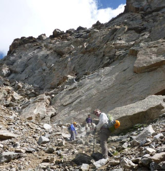
These are some shots showing the grind towards the Mt. Evans peak. The summit remained totally out of sight until we were practically on top of it.
We approached the final summit cap and as we came around, despite the briefings, we were amazed at the civilization we confronted. There was a paved road all the way to 14,135’ which was only 130’ below the summit of Mt. Evans. The structure in the distance is the Meyer-Womble Observatory which is owned and operated by the University of Denver. It is the third highest optical/infrared observatory in the world. It was completed in 1996. During the winter of 2011 when the road is seasonally closed, the dome over the telescope was damaged allowing snow to enter. It was secured by a climber who made a winter ascent to the summit.
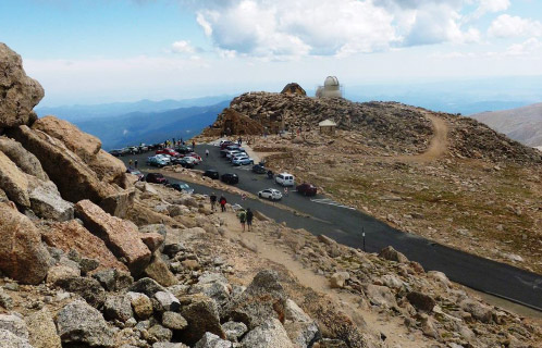
We hiked up the final 130’ (along with others strolling up from the parking lot) to Mt. Evans. We had a brief temptation to hitch a ride down the road, but that wouldn’t be “legit!”

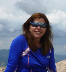
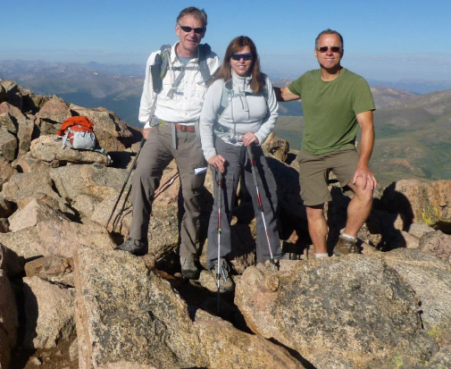
Summit Mt. Evans, 14,264’ at 1:30 pm, 8 hrs. from trailhead; 2 ¼ hrs. from the top of the Sawtooth.
It was going to be a long way down. We had come much further away from the Mt. Bierstadt trailhead to get to Mt. Evans. We estimated we had 5 miles and four hours ahead of us and it was already 1:30 in the afternoon. There was clearly weather coming in the distance. I could see three storm cells, one of which was already pounding Grays and Torreys, two other fourteeners in the front range nearby.
So after taking photos and congratulating each other, we headed back. The return thankfully did not go back over the Sawtooth, rather it stayed high for about a mile (not good being that high for so long in storm conditions) and then descended a steep gully to marshy land far below. There was little wind and the storm cells were moving slowly – that was a good thing.
On descent from Mt. Evans, a grand view opened up: Mt Bierstadt on the left and the Sawtooth in middle. Grays and Torreys (fourteeners) are in the distant upper right.
We got to the gully and began descending on surprisingly good traction under-foot. The clouds were amassing, but the storms rotated around us, not over us.
Laura and Rick C. making their way down the gully.
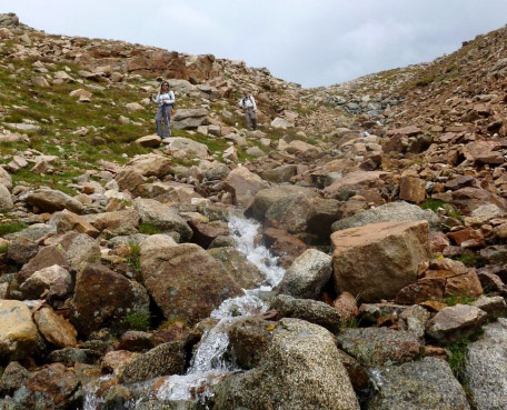
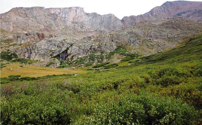
We reached the bottom of the gully into safer territory just as the first deafening clap of thunder vibrated right through our bodies. It looked as though one of the storm cells had made it to the Evans summit but it hung there for a while. That gave us time to do our march through very dense willows and marsh for the 2.5 miles back to the Bierstadt trail.
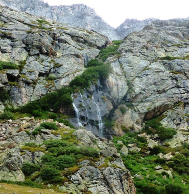
Looking back, we had come down from the upper left and then down the slope above the waterfall to the marsh at about 12,500’ below.
All the way back it was thundering and we saw storm cells moving around in the distance. At one point we donned our rain gear only to experience about 5 minutes of rain drops.
We stayed dry all the way back to the car.
Re-connecting with the Mt. Bierstadt trail not far from the trailhead.
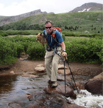
The final stream crossing – this was from the 2011 climb of Mt. Bierstadt with Emme – in all of her 17 fourteeners I’ve lifted her maybe three times. This was one of them because the stream was running strong –she always hated my help.
We got back to the car at 5:30 pm, an exact 12 hour day. The weather held off until we started the three hour drive back to Aspen, when a massive front produced pouring rain and a lightening show. We felt great in the cocoon of our car.
It was an amazing day with fun climbing, great weather, two fourteeners and an exciting traverse … even the P, B and J’s tasted good on the Mt. Evans summit!
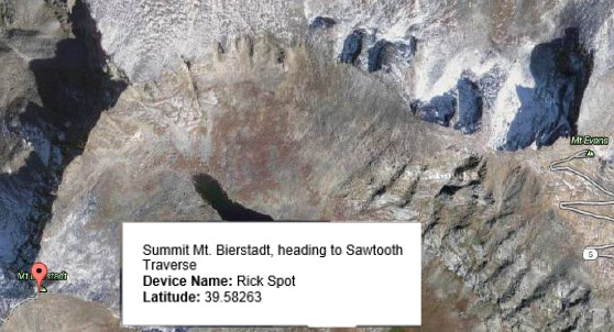
8:30 am August 28, 2013
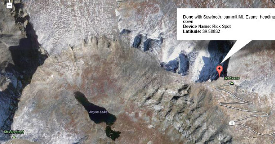
1:30 pm August 28, 2013.
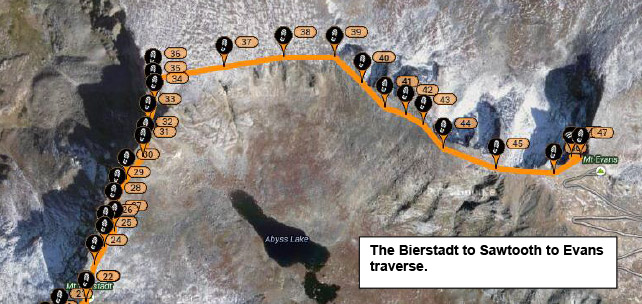
The Bierstadt to Sawtooth to Evans traverse.